
Source: Bureau of Meteorology
Issued at 5:46 am WST on Friday 23 January 2026
Headline:
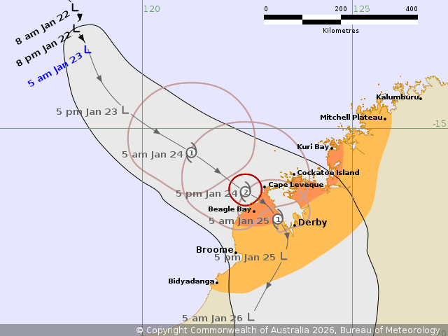
Tropical Low 16U likely to develop into a category 2 tropical
cyclone as it approaches the northwest Kimberley Coast on
Saturday.
Areas Affected:
Warning zone: Beagle Bay to Kuri Bay.
Watch zone: Bidyadanga to Mitchell Plateau, including Broome and
Derby.
Cancelled zone: None.
Details of Tropical Low 16U at 5:00 am AWST:
Intensity: Tropical Low, sustained winds near the centre of 45
kilometres per hour with wind gusts to 85 kilometres per
hour.
Location: within 65 kilometres of 13.1 degrees South 118.7 degrees
East, estimated to be 660 kilometres northwest of Broome and 710
kilometres northwest of Derby.
Movement: south southeast at 6 kilometres per hour.
Tropical Low 16U is currently located to the northwest of the
Kimberley coast.
The system is forecast to intensify as it tracks southeast during
Friday, towards the northwest Kimberley coast.
16U may reach tropical cyclone strength overnight Friday and
intensify to a category 2 system early Saturday, before crossing
the northwest Kimberley coast on Saturday.
Hazards:
DESTRUCTIVE WIND GUSTS to 130 km/h may develop about coastal parts
between Cockatoo Island and Beagle Bay as the system centre
approaches on Saturday.
GALES with DAMAGING WIND GUSTS to 120 km/h are possible between
Kuri Bay and Beagle Bay from late Friday or early Saturday morning
and may extend west to Mitchell Plateau and south to Broome during
Saturday morning. Gales may extend south to Bidyadanga later
Saturday if the system takes a track further west.
HEAVY RAINFALL which may lead to FLASH FLOODING is possible from
late Friday for the northwest Kimberley district, including the
coast and adjacent inland areas during Saturday.
Coastal residents within King Sound are specifically warned of the
potential for a DANGEROUS STORM TIDE as the cyclone centre crosses
the coast. Tides are likely to rise significantly above the normal
high tide, with DAMAGING WAVES and DANGEROUS FLOODING.
Elsewhere, between between Cape Leveque and Cockatoo Island tides
are likely to rise above the normal high tide mark with LARGE WAVES
and MINOR FLOODING of low-lying coastal areas on Saturday as 16U
crosses the Kimberley coast. Tides will be higher than normal
between Beagle Bay and Mitchell Plateau on Saturday.
Recommended Action:
Ensure you know what to do in a cyclone. For the latest DFES
community alerts and warnings visit www.emergency.wa.gov.au or
download the Emergency WA app.
Current
Tropical Cyclones
22/Jan/2026 09:54 PM

