
Source: Bureau of Meteorology
Issued at 5:47 am WST on Saturday 24 January 2026
Headline:
Tropical Cyclone Luana to cross the northwest Kimberley coast
today as a category 2 system.
Areas Affected:
Warning zone: Broome to Kuri Bay, including Derby and adjacent
inland areas.
Watch zone: Bidyadanga to Broome and adjacent inland area.
Cancelled zone: Between Kuri Bay and Mitchell Plateau.
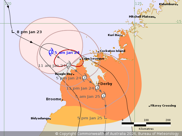
Details of Tropical Cyclone Luana 16U at 5:00 am AWST:
Intensity: Category 1, sustained winds near the centre of 75
kilometres per hour with wind gusts to 100 kilometres per
hour.
Location: within 35 kilometres of 16.1 degrees South 121.8 degrees
East, estimated to be 210 kilometres north northwest of Broome and
125 kilometres west northwest of Cape Leveque.
Movement: east southeast at 22 kilometres per hour.
Tropical Cyclone Luana has formed and is forecast to intensify to
a category 2 system prior to making landfall on the northwest
Kimberley coast later today.
The most likely crossing location is between north of Broome and
Cockatoo Island.
After landfall over the Dampier Peninsula, Luana may move back
over the waters of King Sound where it is forecast to maintain
category 2 intensity until making landfall again near Derby. It
will weaken and be below tropical cyclone strength during Sunday
morning after moving further inland.
Hazards:
DESTRUCTIVE WIND GUSTS to 140 km/h may develop near the system
centre between Beagle Bay and Cockatoo Island today as the system
approaches and moves over the coast.
GALES with DAMAGING WIND GUSTS to 120 km/h are possible between
Beagle Bay and Kuri Bay from early this morning. Gales may extend
south to Derby and towards Broome this afternoon, and to adjacent
inland areas overnight tonight. The risk of the system taking a
track further west is decreasing, though if it does gales may
extend from Broome to Bidyadanga later today.
HEAVY RAINFALL which may lead to FLASH FLOODING is possible for
the northwest Kimberley district, including the coast and adjacent
inland areas today.
Coastal residents within King Sound are specifically warned of the
potential for a DANGEROUS STORM TIDE as the cyclone passes over the
Sound. Tides are likely to rise significantly above the normal high
tide, with DAMAGING WAVES and DANGEROUS FLOODING.
Tides will be higher than normal between Beagle Bay and Kuri Bay
today and LARGE WAVES may produce MINOR FLOODING of low-lying
coastal areas as the system crosses the coast.
Recommended Action:
Ensure you know what to do in a cyclone. For the latest DFES
community alerts and warnings visit www.emergency.wa.gov.au or
download the Emergency WA app.
Current
Tropical Cyclones
23/Jan/2026 09:56 PM

