
Source: Bureau of Meteorology
TROPICAL CYCLONE ADVICE NUMBER 36
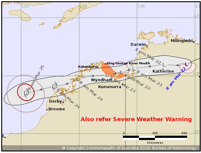
Issued at 10:25 am ACST on Sunday 22 March 2026
Headline:
Ex-Tropical Cyclone Narelle has crossed the eastern Top End coast
and weakened below tropical cyclone strength.
Areas Affected:
Warning Zone
King George River Mouth to WA/NT Border.
Watch Zone
None.
Cancelled Zone
Milingimbi to Nathan River, including Nhulunbuy, Galiwin'ku,
Numbulwar, Alyangula, Gapuwiyak, Bulman, and Ngukurr.
Details of Ex-Tropical Cyclone Narelle 34U at 9:30 am ACST:
Intensity: Tropical Low, sustained winds near the centre of 75
kilometres per hour with wind gusts to 100 kilometres per
hour.
Location: within 45 kilometres of 14.0 degrees South 134.3 degrees
East, estimated to be 230 kilometres west of Alyangula and 225
kilometres east northeast of Katherine.
Movement: west southwest at 33 kilometres per hour.
Ex-Tropical Cyclone Narelle has weakened below tropical cyclone
strength south of Bulman. The system will weaken further over the
coming hours and track across the Top End on Sunday and early
Monday as a tropical low. A Severe Weather Warning is current for
heavy, locally intense rainfall and damaging winds.
During Monday, Narelle is expected to move over the Joseph
Bonaparte Gulf and gales are forecast to redevelop to the north of
the centre. There is a Low chance that Narelle redevelops into a
tropical cyclone while in the Joseph Bonaparte Gulf near the NT/WA
Border.
Hazards:
Northern Territory:
Ex-Tropical Cyclone Narelle has weakened below tropical cyclone
strength and the latest Severe Weather Warning should be referred
to as GALES with DAMAGING WIND GUSTS and HEAVY, LOCALLY INTENSE
RAINFALL remains possible over parts of the Top End.
Western Australia:
GALES with DAMAGING WIND GUSTS to 90 km/h are possible between
King George River Mouth and the WA/NT border during Monday.
HEAVY RAINFALL which may lead to FLASH FLOODING is possible for
the north Kimberley during Monday.
Recommended Action:
NTES advises:
- For cyclone preparedness and safety advice, visit the Secure NT
website at https://securent.nt.gov.au
- For emergency assistance call the Northern Territory Emergency
Service (NTES) on 132 500 (for assistance with storm damage, rising
flood water, fallen trees on buildings or roof damage).
DFES advises:
Ensure you know what to do in a cyclone. For the latest DFES
community alerts and warnings visit www.emergency.wa.gov.au or
download the Emergency WA app.
Current
Tropical Cyclones
22/Mar/2026 01:11 AM

