
Source: Bureau of Meteorology
Issued at 5:21 pm WST on Tuesday 30 December 2025
Headline:
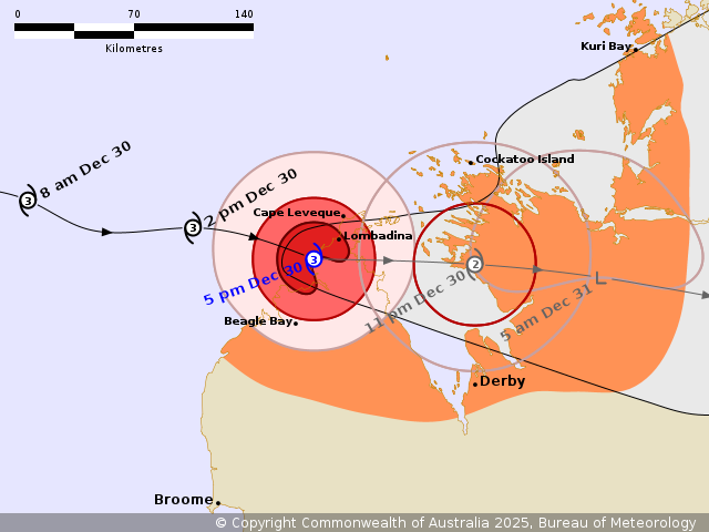
Severe Tropical Cyclone Hayley is crossing the coast of the
northern Dampier Peninsula, just to the south of
Lombadina/Djarindjin.
Areas Affected:
Warning Zone
North of Broome to Kuri Bay, including central and northern parts
of the Dampier Peninsula and Derby.
Watch Zone
None.
Cancelled Zone
Southern parts of the Dampier Peninsula.
Details of Severe Tropical Cyclone Hayley 08U at 5:00 pm
AWST:
Intensity: Category 3, sustained winds near the centre of 120
kilometres per hour with wind gusts to 165 kilometres per
hour.
Location: within 20 kilometres of 16.6 degrees South 122.8 degrees
East, estimated to be 20 kilometres southwest of Lombadina and 160
kilometres north northeast of Broome.
Movement: east at 23 kilometres per hour.
Severe Tropical Cyclone Hayley, category 3, is crossing the
Kimberley coast over the northern Dampier Peninsula, just to the
south of Lombadina/Djarindjin. The destructive to very destructive
core is currently impacting communities over the northern Dampier
Peninsula.
Hazards:
VERY DESTRUCTIVE WIND GUSTS to 170 km/h are possible about the
northern Dampier Peninsula this evening, from the north of Beagle
Bay through to Cape Leveque.
DESTRUCTIVE WIND GUSTS to 150 km/h are likely about the northern
Dampier Peninsula until later this evening, and could extend east
to coastal areas south of Cockatoo Island overnight or early
Wednesday morning.
GALES with DAMAGING WIND GUSTS to 100 km/h are occurring over the
northern Dampier Peninsula, and should extend east to Cockatoo
Island during the evening and overnight, and possibly as far south
as Derby. Gales may extend further north to Kuri Bay early
Wednesday.
HEAVY RAINFALL which could lead to FLASH FLOODING is possible as
Hayley crosses the coast and moves inland. Heavy rainfall may
extend further inland through to the central Kimberley during
Wednesday as the remnants of Hayley move further inland, and a
separate Severe Weather Warning has been issued.
Tides will be higher than normal in some parts of the warning area
as Hayley crosses the west Kimberley Coast.
Recommended Action:
DFES Advises: Ensure you know what to do in a cyclone. For the
latest DFES community alerts and warnings visit
www.emergency.wa.gov.au or download the Emergency WA app.
Current
Tropical Cyclones
30/Dec/2025 09:35 AM

