
Source: Bureau of Meteorology
TROPICAL CYCLONE ADVICE NUMBER 16
Issued at 7:10 pm WST on Saturday 7 February 2026
Headline:
Severe Tropical Cyclone Mitchell (21U) has strengthened to
category 3 north of Karratha.
Areas Affected:
Warning Zone
Port Hedland to Coral Bay, including Port Hedland, Karratha,
Onslow, and Exmouth, and extending inland through the western
Pilbara to include Pannawonica.
Watch Zone
Coral Bay to Carnarvon and adjacent inland areas.
Cancelled Zone
None.
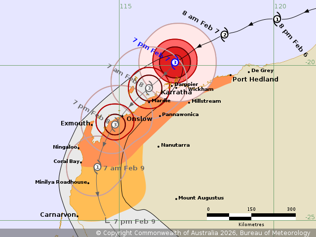
Details of Severe Tropical Cyclone Mitchell 21U at 7:00 pm
AWST:
Intensity: Category 3, sustained winds near the centre of 130
kilometres per hour with wind gusts to 185 kilometres per
hour.
Location: within 30 kilometres of 19.9 degrees South 116.8 degrees
East, estimated to be 95 kilometres north of Karratha and 195
kilometres west northwest of Port Hedland.
Movement: west southwest at 18 kilometres per hour.
Severe Tropical Cyclone Mitchell (21U) is intensifying north of
Karratha and is now at category 3 strength.
Severe Tropical Cyclone Mitchell is forecast to move to the
southwest closer to the Pilbara coast this evening, and then track
close to the west Pilbara coast during Sunday. Late on Sunday it is
forecast to move over land near Onslow, before taking a more
southerly track over land during Monday.
Hazards:
VERY DESTRUCTIVE WIND GUSTS to 220 km/h are possible over the
coastal parts of the Pilbara around Karratha, Dampier and Wickham
tonight especially if Mitchell moves closer than forecast,
extending to Onslow during Sunday as the destructive core of
Mitchell moves along the coast.
DESTRUCTIVE WIND GUSTS to 160 km/h are forecast around Karratha,
Dampier and Wickham tonight, extending west towards Onslow during
Sunday and possibly Exmouth Sunday night.
GALES with DAMAGING WIND GUSTS to 120 km/h are possible along the
coastal parts between Port Hedland and Dampier, extending west to
Onslow and Exmouth and through inland parts of the western Pilbara,
including Pannawonica.
Widespread moderate to HEAVY RAINFALL which may lead to FLASH
FLOODING is likely from later today with this risk persisting
through the weekend for the central and west Pilbara coast,
extending to the west Gascoyne region on Monday. Local areas of
INTENSE rainfall leading to SEVERE FLASH FLOODING may develop
around the central Pilbara coast west of Wickham overnight and
Sunday morning.
ABNORMALLY HIGH TIDES could cause SERIOUS FLOODING in the Karratha
region early Sunday morning, and then in the Onslow region on the
Sunday afternoon.
Elsewhere on the west Pilbara coast including Exmouth, tides are
likely to rise above the normal high tide mark on Saturday and
Sunday which may produce FLOODING of low-lying coastal areas.
Current
Tropical Cyclones
07/Feb/2026 11:18 AM


