
Source: Bureau of Meteorology
Issued at 2:44 am WST on Saturday 12 April 2025
Headline:
Tropical cyclone expected to develop in the Timor Sea later
today.
Areas Affected:
Warning Zone
None.
Watch Zone
Cockatoo Island to Berkeley River Mouth.
Cancelled Zone
None.
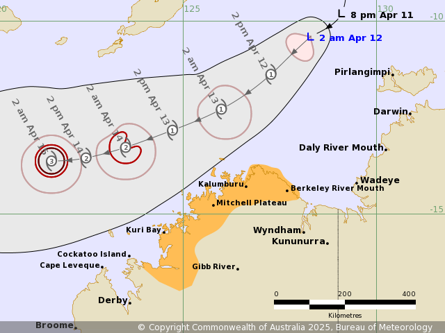
Details of Tropical Low 29U at 2:00 am AWST:
Intensity: Tropical Low, sustained winds near the centre of 65
kilometres per hour with wind gusts to 95 kilometres per
hour.
Location: within 55 kilometres of 10.4 degrees South 128.3 degrees
East, estimated to be 360 kilometres northwest of Darwin and 255
kilometres west northwest of Pirlangimpi.
Movement: southwest at 16 kilometres per hour.
Tropical Low 29U is located to the northwest of Darwin and is
moving southwest. It is expected to develop into a tropical cyclone
later today.
29U will continue moving southwest across the Timor Sea over the
weekend. It is expected to pass to the north of the Kimberley coast
during Sunday. Increased wind and wave impacts are expected along
the Kimberley coast from later today.
Hazards:
Gales with DAMAGING WIND GUSTS could develop between Kuri Bay and
Berkeley River Mouth on Saturday night or early Sunday, if the
track shifts further south than the current forecast.
Gales with DAMAGING WIND GUSTS could develop between Kuri Bay and
Cockatoo Island during Sunday, only if the track shifts further
southwards than the current forecast.
HEAVY RAINFALL may develop along the coastal areas between Kuri
Bay and Berkeley River Mouth, tonight or on Sunday, as 29U moves
past the Kimberley coast on Sunday morning.
As the system moves past, tides between Kuri Bay and Berkeley
River Mouth may rise above the normal high tide mark, but the sea
level should not exceed the highest tide of the year.
Recommended Action:
DFES advises: Ensure you know what to do in a cyclone. For the
latest DFES community alerts and warnings visit
www.emergency.wa.gov.au or download the Emergency WA app.
Current
Tropical Cyclones
11/Apr/2025 08:15 PM


