
Source: Bureau of Meteorology
Media: Transmitters serving the Tiwi Islands and the area near and
between Cape Hotham to Point Stuart are requested to USE the
Standard Emergency Warning Signal before broadcasting the following
warning.
TOP PRIORITY FOR IMMEDIATE BROADCAST
TROPICAL CYCLONE ADVICE NUMBER 23
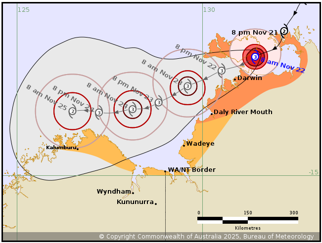
Issued at 9:54 am ACST on Saturday 22 November 2025
Headline:
Severe Tropical Cyclone Fina, Category 3, to pass just north of
Darwin later today. Darwin to experience rapid increase in winds
later this afternoon and evening.
Areas Affected:
Warning zone: Daly River Mouth to Cape Don, including Tiwi
Islands, Dundee Beach, Darwin, Milikapiti, Pirlangimpi and
Wurrumiyanga.
Watch zone: Troughton Island to Wadeye.
Cancelled zone: None.
Details of Severe Tropical Cyclone Fina 02U at 9:30 am ACST:
Intensity: Category 3, sustained winds near the centre of 120
kilometres per hour with wind gusts to 165 kilometres per
hour.
Location: within 20 kilometres of 11.8 degrees South 131.4 degrees
East, estimated to be 90 kilometres northeast of Darwin and 85
kilometres east of Wurrumiyanga.
Movement: west southwest at 9 kilometres per hour.
Severe Tropical Cyclone Fina is moving west southwest across the
Van Diemen Gulf and is expected to pass north of Darwin later
today.
After passing Darwin, Fina is forecast to maintain severe tropical
cyclone intensity on Sunday or early Monday as it moves through the
southern Timor Sea, and then start weakening during Monday or
Tuesday near the Kimberley coast.
Hazards:
VERY DESTRUCTIVE WIND GUSTS to 185 km/h are likely along the
southeastern coast of Tiwi Islands this morning, moving west during
the day, with a chance of reaching Wurrumiyanga later today. Very
destructive wind gusts are likely about exposed coastal sites
northeast of Darwin today but the risk at Darwin Is assessed as
low.
DESTRUCTIVE WIND GUSTS to 155 km/h are occurring over southeastern
parts of the Tiwi Islands, and likely to extend west to southern
parts of the islands, including Wurrumiyanga during the day.
Destructive gusts are expected to extend to the Darwin region later
today.
GALES with DAMAGING WIND GUSTS to 120 km/h are occurring over the
Cobourg Peninsula, eastern parts of Melville Island and Cape Hotham
to Point Stuart.
Gales are expected to extend further west to include Darwin this
afternoon and across the remainder of the Tiwi Islands during the
day. Gales may extend southwest to Daly River Mouth overnight, and
if Fina takes a more southerly track, gales Could extend south to
Wadeye on Sunday.
Later Sunday or on Monday, GALES may extend to coastal parts of
the north Kimberley in WA, from Kalumburu to the WA/NT Border, but
not including Wyndham or Kununurra.
HEAVY to LOCALLY INTENSE RAINFALL which may lead to FLASH FLOODING
is possible along coastal areas between the Tiwi Islands and the
Cobourg Peninsula, extending to coastal and adjacent inland areas
across the western Top End including Darwin later today and on
Sunday.
Coastal residents on the Tiwi Islands, and between Cape Hotham and
Warruwi are specifically warned that tides are likely to rise above
the normal high tide mark with LARGE WAVES and MINOR FLOODING of
low-lying coastal areas.
Recommended Action:
NTES advises people in the path of the dangerous cyclone about
southern Melville Island and Cape Hotham to Point Stuart, should
stay calm and remain in a secure shelter while the destructive
winds continue. Do not venture outside if you find yourself in the
eye of the cyclone - destructive winds from a different direction
could resume at any time. Heed the advice and follow the
instructions of Emergency Services personnel and local
authorities.
NTES advises people on the Tiwi Islands, and elsewhere between
Daly River Mouth to Cape Don, including Darwin, Batchelor and
Cobourg Peninsula should immediately commence or continue
preparations, especially securing boats and property, using
available daylight hours. NTES advises people elsewhere near and
between Wadeye and south of Daly River Mouth, should consider what
action they will need to take if the cyclone threat increases. For
cyclone preparedness and safety advice, visit the Secure NT website
(https://securent.nt.gov.au
Current
Tropical Cyclones
22/Nov/2025 12:53 AM

