
Source: Bureau of Meteorology
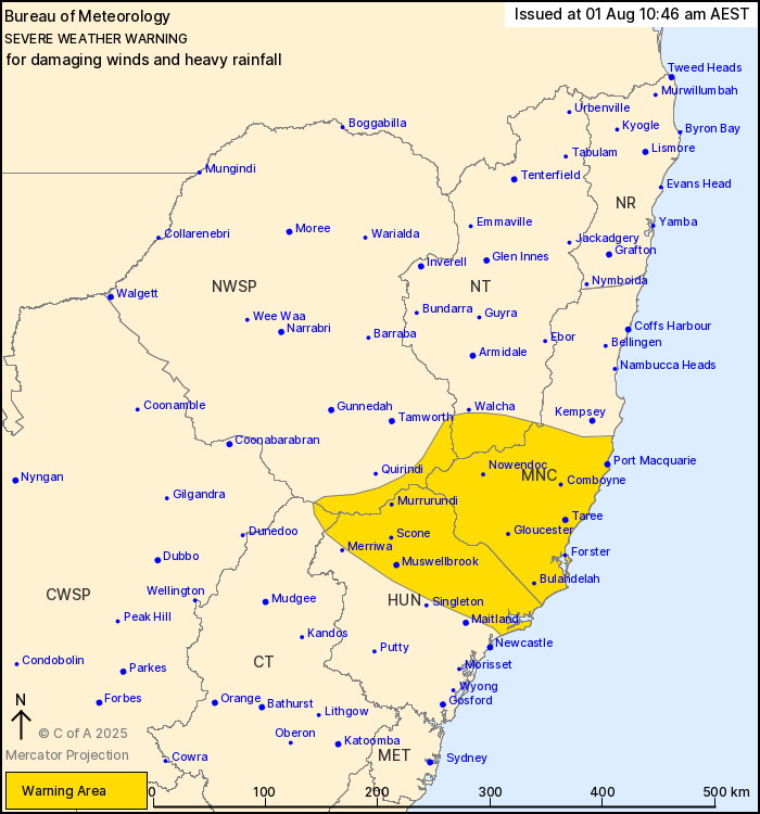
For people in parts of Mid North Coast, Hunter, North West Slopes
and Plains, Northern Tablelands and Central Tablelands Forecast
Districts.
Issued at 10:46 am Friday, 1 August 2025.
Damaging winds and heavy rainfall to impact central eastern NSW
from Saturday afternoon.
Weather Situation: A low pressure system and coastal trough is
forecast to develop off the northeast coast during Saturday before
tracking west over land during the late afternoon. This system is
bringing a strong east to southeasterly flow on its southern and
southwestern flanks. A second low pressure system will develop
offshore of the NSW and Queensland border on Sunday.
For COASTAL AREAS: Strong easterly winds averaging 50 to 60 km/h
with DAMAGING WIND GUSTS of around 90 km/h are likely to develop
about the coastal fringe from early Saturday afternoon. Winds are
forecast to ease below warning thresholds late Saturday
night.
For INLAND AREAS: Southeasterly DAMAGING WINDS averaging 55 to 65
km/h with peak gusts of around 90 km/h are possible over elevated
areas from late Saturday afternoon, easing overnight. HEAVY
RAINFALL which may lead to FLASH FLOODING is also forecast about
inland parts of the Hunter, Mid North Coast and Northern Tablelands
from Saturday afternoon. Six-hourly rainfall totals between 50 and
80 mm are likely, with isolated totals up to 100 mm possible about
elevated areas. 24-hourly rainfall totals between 75 and 90 mm are
likely, with isolated totals up to 120 mm possible about elevated
areas. Rainfall is likely to ease below warning thresholds early
Sunday morning.
On Sunday, DAMAGING WINDS may also develop over the Northern
Rivers and parts of the Mid North Coast as the second low pressure
system moves closer to the northern NSW coastline.
Flood Watches and Warnings are current for eastern catchments.
Please refer to http://www.bom.gov.au/nsw/warnings/
Locations which may be affected include Port Macquarie, Taree,
Scone, Comboyne, Nowendoc, Gloucester, Forster, Bulahdelah and
Muswellbrook.
The State Emergency Service advises that people should:
* Don't drive, ride or walk through flood water.
* Keep clear of creeks and storm drains.
* If you are trapped by flash flooding, seek refuge in the highest
available place and ring 000 if you need rescue.
* Be aware that run-off from rainfall in fire affected areas may
behave differently and be more rapid. It may also contain debris
such as ash, soil, trees and rocks.
* After bushfires, heavy rain and the loss of foliage can make the
ground soft and heavy, leading to a greater chance of
landslides.
* Move vehicles under cover or away from trees.
* Secure or put away loose items around your house, yard and
balcony.
* Keep at least 8 metres away from fallen power lines or objects
that may be energised, such as fences.
* Trees that have been damaged by fire are likely to be more
unstable and more likely to fall.
* Report fallen power lines to either Ausgrid (131 388), Endeavour
Energy (131 003), Essential Energy (132 080) or Evoenergy (131 093)
as shown on your power bill.
* Stay vigilant and monitor conditions. Note that the landscape
may have changed following bushfires.
* For emergency help in floods and storms, ring your local SES
Unit on 132 500.
01/Aug/2025 12:53 AM

