
Source: Bureau of Meteorology
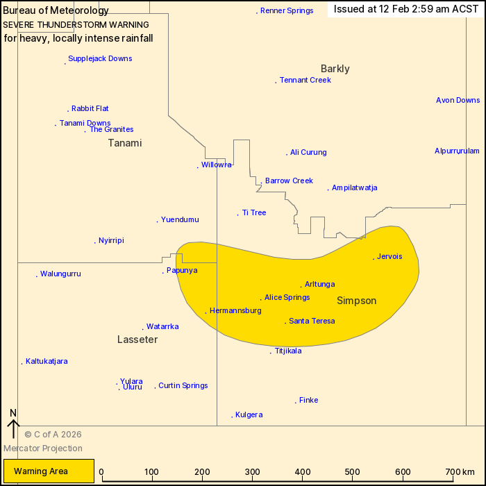
For people in parts of Simpson, Lasseter, Barkly and Tanami
districts.
Issued at 2:59 am Thursday, 12 February 2026.
HEAVY, LOCALLY INTENSE RAIN A RISK WITH THUNDERSTORMS IN SOUTHERN
NT EARLY THURSDAY MORNING.
Weather Situation: A moist, unstable air mass persists over the
Northern Territory, feeding the potential for severe
thunderstorms.
VERY DANGEROUS THUNDERSTORMS are likely to produce heavy, locally
intense rainfall that may lead to dangerous and life-threatening
flash flooding in the warning area over the next several hours.
Locations which may be affected include Alice Springs, Arltunga,
Jervois, Hermannsburg, Santa Teresa and Simpson District east of
Finke.
98MM RECORDED IN 2 HOURS TO 2:18AM AT MOUNT LLOYD, INCLUDING 48MM
IN 30 MINUTES TO 1:45AM
49mm recorded in 1 hour to 2:07am at Wigley Gorge
The Northern Territory Emergency Service advises that people
should:
* slow down and turn your headlights on
* create your own sandbags if there is flooding, by using pillow
cases or shopping bags filled with sand and place them around
doorways to protect your home
* secure loose outside objects
* ensure pets and animals are safe
* avoid remaining in the open when storms threaten
* pull over if it is raining heavily and you cannot see, park with
your hazard lights on until the rain clears
* avoid driving into water of unknown depth and current
* for emergency help in floods, storms and cyclones, contact the
NTES on 132 500. For more safety tips visit
www.securent.nt.gov.au
11/Feb/2026 05:35 PM


