
Source: Bureau of Meteorology
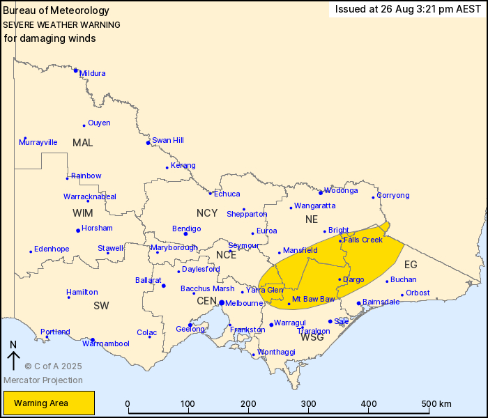
For people in parts of East Gippsland, North Central, North East,
West and South Gippsland and Central Forecast Districts.
Issued at 3:21 pm Tuesday, 26 August 2025.
Damaging winds easing from central and western areas, continuing
over the eastern ranges into Wednesday.
Weather Situation: A cold front that brought damaging wind gusts
to western and central Victoria including Melbourne today has now
shifted to the east of the state, increasing the risk of damaging
winds over the eastern ranges for the remainder of the day. A
second front will bring a renewed burst of vigorous winds to the
eastern ranges on Wednesday.
For EASTERN RANGES:
DAMAGING NORTHWESTERLY WINDS averaging 55 to 65 km/h with peak
gusts to around 110 km/h are likely to develop this
afternoon.
Winds may temporarily ease on early morning Wednesday before
increasing again as the second front approaches during the
mid-morning on Wednesday. Winds should ease below warning
thresholds by late Wednesday afternoon or evening.
Locations which may be affected include Falls Creek, Dargo, Mt Baw
Baw, Mt Hotham, Mt Buller and Omeo.
Severe weather is no longer occurring in the South West and
Wimmera districts and the warning for these districts is
CANCELLED.
Significant wind observations to 3:00 pm.
91 km/h gust at Mt Hotham at 2:43 pm.
91 km/h gust at Essendon Airport at 1:13pm.
98 km/h gust at Melbourne Airport at 12:43 pm.
100 km/h gust at St Kilda Harbour at 12:05 pm.
107 km/h gust was recorded at Mount WIlliam at 4:02 am.
The State Emergency Service advises that people should:
* If driving conditions are dangerous, safely pull over away from
trees, drains, low-lying areas and floodwater. Avoid travel if
possible.
* Stay safe by avoiding dangerous hazards, such as floodwater,
mud, debris, damaged roads and fallen trees.
* Be aware - heat, fire or recent storms may make trees unstable
and more likely to fall when it's windy or wet.
* Check that loose items, such as outdoor settings, umbrellas and
trampolines are safely secured. Move vehicles under cover or away
from trees.
* Stay indoors and away from windows.
* If outdoors, move to a safe place indoors. Stay away from trees,
drains, gutters, creeks and waterways.
* Stay away from fallen powerlines - always assume they are
live.
* Be aware that in fire affected areas, rainfall run-off into
waterways may contain debris such as ash, soil, trees and rocks.
Heavy rainfall may also increase the potential for landslides and
debris across roads.
* Stay informed: Monitor weather warnings, forecasts and river
levels at the Bureau of Meteorology website, and warnings through
VicEmergency website/app/hotline.
26/Aug/2025 05:32 AM

