
Source: Bureau of Meteorology
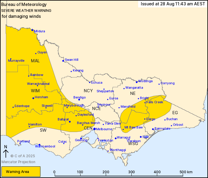
For people in Mallee, Wimmera and parts of Central, East
Gippsland, South West, North Central, North East, West and South
Gippsland and Northern Country Forecast Districts.
Issued at 11:43 am Thursday, 28 August 2025.
Damaging winds associated with an approaching front on Friday
morning. Blizzards possible for alpine areas.
Weather Situation: A strong northwesterly airstream will develop
across the state early on Friday morning ahead of an approaching
frontal system in the west. This flow will initially affect the
eastern ranges, before developing about the central ranges before
sunrise. The front is expected to enter the west of the state after
sunrise, with damaging winds possible in showers and isolated
thunderstorms along and behind it.
For the EASTERN RANGES: DAMAGING northwesterly winds averaging 65
to 75 km/h with gusts around 110 km/h are likely to develop early
on Friday morning.
For the MACEDON RANGES INCLUDING MELBOURNE'S OUTER NORTHERN
SUBURBS: Strong to DAMAGING northwesterly winds averaging 50 to 65
km/h with peak gusts up to 100 km/h are likely to develop before
sunrise in the Macedon Ranges and foothills on Friday morning
before sunrise. Winds will extend down towards Melbourne's outer
northern and northwestern suburbs, including Melbourne airport,
from the late morning.
For WESTERN VICTORIA: DAMAGING wind gusts around 90 km/h are
possible for a brief period in a line of showers and isolated
thunderstorms as the front moves east across the warning
area.
BLIZZARD conditions are forecast for parts of the Eastern Ranges
above 1400m.
Damaging winds are expected to continue throughout Friday, with
the warning area likely to expand as a vigorous southwesterly
airstream approaches the state in the late afternoon.
Locations which may be affected include Melbourne Airport,
Mildura, Horsham, Maryborough, Ballarat, Stawell, Hamilton, Bacchus
Marsh, Mt Hotham and Mt Buller.
The State Emergency Service advises that people should:
* If driving conditions are dangerous, safely pull over away from
trees, drains, low-lying areas and floodwater. Avoid travel if
possible.
* Stay safe by avoiding dangerous hazards, such as floodwater,
mud, debris, damaged roads and fallen trees.
* Be aware - heat, fire or recent storms may make trees unstable
and more likely to fall when it's windy or wet.
* Check that loose items, such as outdoor settings, umbrellas and
trampolines are safely secured. Move vehicles under cover or away
from trees.
* Stay indoors and away from windows.
* If outdoors, move to a safe place indoors. Stay away from trees,
drains, gutters, creeks and waterways.
* Stay away from fallen powerlines - always assume they are
live.
* Be aware that in fire affected areas, rainfall run-off into
waterways may contain debris such as ash, soil, trees and rocks.
Heavy rainfall may also increase the potential for landslides and
debris across roads.
* Stay informed: Monitor weather warnings, forecasts and river
levels at the Bureau of Meteorology website, and warnings through
VicEmergency website/app/hotline.
28/Aug/2025 01:51 AM

