
Source: Bureau of Meteorology
Issued at 2:51 pm WST on Thursday 5 February 2026
Headline:
Tropical Low 21U is expected to develop off the north Pilbara
coast.
Areas Affected:
Warning zone: None.
Watch zone: Onslow to Port Hedland, including Karratha.
Cancelled zone: None.
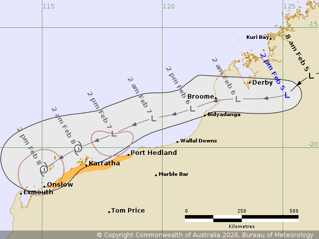
Details of Tropical Low 21U at 2:00 pm AWST:
Intensity: Tropical Low, sustained winds near the centre of 30
kilometres per hour with wind gusts to 75 kilometres per
hour.
Location: within 65 kilometres of 17.8 degrees South 125.2 degrees
East, estimated to be 750 kilometres east northeast of Port Hedland
and 315 kilometres east of Broome.
Movement: southwest at 23 kilometres per hour.
Tropical Low 21U is moving to the west over the central Kimberley.
It is expected to move offshore of the Kimberley coast during
Friday. Once offshore, 21U is expected to develop over waters off
the Pilbara coast during the weekend.
21U is forecast to move in a general west southwest direction,
remaining parallel to the Pilbara coast during the weekend. From
Monday onwards, 21U is likely to begin weakening and turning
towards the coast south of Exmouth, possibly moving over
land.
Hazards:
GALES with DAMAGING WIND GUSTS to 120 km/h are possible for
coastal parts between Onslow and Port Hedland during
Saturday.
Widespread moderate to locally HEAVY RAINFALL which may lead to
FLASH FLOODING is possible from late Friday for the Pilbara
coast.
Recommended Action:
Ensure you know what to do in a cyclone. For the latest DFES
community alerts and warnings visit www.emergency.wa.gov.au or
download the Emergency WA app.
Next Advice:
The next advice will be issued by 9:00 pm AWST Thursday 05
February.
Current
Tropical Cyclones
05/Feb/2026 07:10 AM


